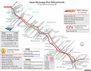
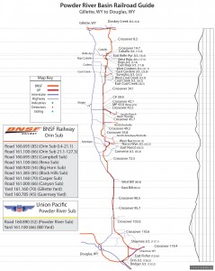
The two railroad maps below can be downloaded and used for free. They were made in 2010 and some information on the maps has changed since they were made. Neither map was 100% completed, so there is missing information on both maps. To download the maps below: Click on the map (should open full size in new window), Right-click copy image.
This railroad map of the Upper Mississippi River covers the BNSF and Canadian Pacific trackage between St. Paul, Minnesota and La Crosse, Wisconsin.
Major Roadways included: I-94, I-90, US-61, and WIS-35
Notable Cities included: Newport, St. Croix, Hastings, Red Wing, Alma, Wabasha, Winona, and Fountain City
Railway Companies included: BNSF, Canadian Pacific, Amtrak, Canadian National, and former DM&E and IC&E.
Subdivisions: BNSF St. Croix Sub, CP River Sub
This map also includes railroad scanner frequencies, Amtrak times and stations, along with an Amtrak status update phone number.
Disclaimer: This map is outdated and incomplete.
This Powder River Basin Railroad Guide will help you find your way around the famous coal deposits of the PRB. This map includes BNSF and Union Pacific trackage between Douglas and Gillette, Wyoming. Also included on this map; mileposts, crossovers, towns, roads, station names, junctions, and scanner frequencies. There is also a corresponding elevation chart on the right of the Orin Subdivision.
Major Roadways included: I-90, I-25, WY-59, and WY-450
Notable Cities included: Gillette, Douglas, Wright, Bill, and Shawnee
Railway Companies included: BNSF, Union Pacific
Subdivisions: BNSF Orin Sub, Reno Sub
Notable Junctions: Donkey Creek, Reno, Shawnee, Orin, Bridger, Caballo, Converse, Coal Creek, Jacobs Ranch, North Rochelle
Notable Coal Mines: Black Thunder, Rojo Caballo, Antelope, Coal Creek, Codero, Belle Ayr
Disclaimer: This map is outdated and unfinished. Roads in this area can change.
Click and Explore
